Showing posts with label trails. Show all posts

Friday, 16 November 2012

Whytecliff Park [PPR: Local's Perspective]

Located at the very end of Marine Dr.

Throughout the summer of my epic journey, people have been asking me if I'd found the perfect park yet. I told them I already knew which one it was, but I was saving it for last. I knew right from the beginning that, at least for me, Whytecliff Park is the perfect 10. Let me explain why.


At the very end of Marine Drive exists a park that has everything. Since it has everything (I'm serious about that, by the way), Whytecliff Park is really big. It's got a whole ton of grassy space that wouldn't be good for any formal sports because it's on a little bit of a slant, but is perfect for casual games of all sorts.


The grass is really nice and soft, and full of surprises. Despite wide open spaces, there's also a lot of big trees in Whytecliff Park. Some of them are climbable if you've got some skills in that area.

Also pictured above is a picnic shelter. There's only two of these in all of West Vancouver (the other one is at John Lawson Park), which is a shame because they're great for so many things. There's a barbeque and a bunch of tables under there, making it the ideal location to hold an evening party in the spring or summer. But it's also great for colder rainy days when you want to be out of the rain but still outside. I haven't actually done this yet, but I'd really like to bring a set of speakers here on a day when it's pouring rain and have a dance party on the tables. Basically, picnic shelter = party central.

Of course, the perfect park would not be complete without a playground and kids playing on it.


This picture is terrible because it's far away and has a tree in the way, but you can still tell the playground exists. It's got a motorcycle rocker, a train, tall swings, and a big structure with slides, tic tac toe, bridges, and all that good stuff. It's not the best playground I've ever been to, but it's definitely up there. Besides, artificial play stuff isn't really the point of Whytecliff.

The point of WhyteCLIFF Park is the CLIFFS! You're probably wondering where they are at this point. Here they are:


The cliffs are nice and rugged, just like a Howe Sound shoreline should be. They're full of crevices to explore. I still find new things even after all these years of visiting. Despite all the chaos of the rocks, there's actually benches all over the cliffs. This is my favorite one:


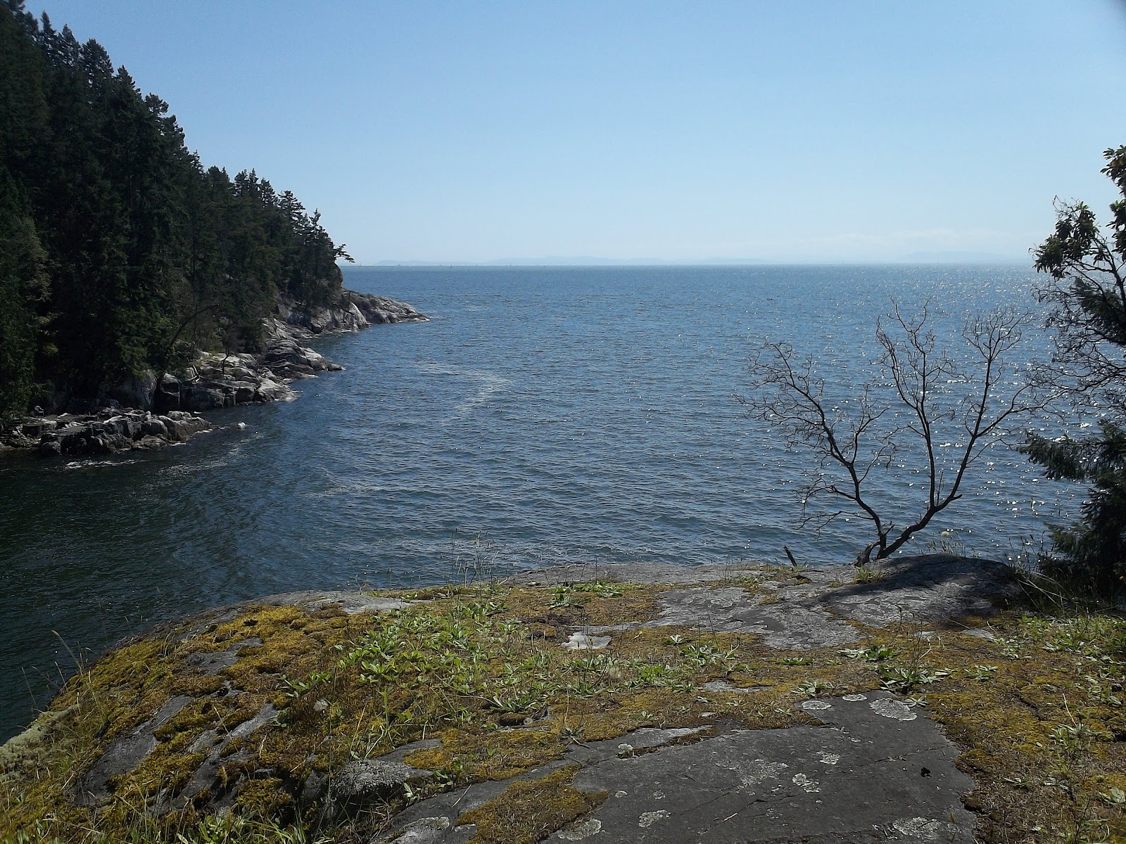
It's one of the most ridiculously placed benches. You actually can't reach it safely without maintaining three points of contact. And obviously, it faces one of the many incredible views from the cliffs. This one is of Whyte Island and Passage Island. Other views feature Bowen Island's marina as well.

In between two cliffs, there's a spot that is known locally as "couple's beach".


It's hidden and the perfect size for two. If you ever happen to be trying to impress a hopeless romantic, then take them here. They'll love it. This park has always reminded me of something out of a movie set in the 50's where teenagers drive around in convertibles and go on dates.

Fun fact: Whytecliff is something out of a movie. A few things have been filmed here, including Scooby Doo. They built the haunted mansion up on the cliffs.

If you were thinking that couple's beach is a little small for your tastes, don't you worry. Just one more cliff over is Whyte Bay.

Hey look, sand! Unfortunately, the sand doesn't go too much further down the beach, but it's a great swimming spot nonetheless. I've swam here many times and actually enjoyed it. That's a lot coming from me. I hate swimming.

Because I hate swimming, I have never tried scuba diving, but everyone says that Whytecliff Park is one of the best dive spots in North America. It's Canada's first marine protected area. It even has its own tank at the Vancouver Aquarium. The Day I went to take pictures, there must have been a hundred people in scuba gear around. A lot of them were there taking lessons. The sheltered bay is great for beginners.

Whyte Bay is also a great one for collecting beach glass, particularly at lower tides. The tiny pebbles that are underwater in the picture are perfect for grinding down broken glass.

Another great thing about low tide at Whytecliff is the opportunity it provides to explore Whyte Island.


When the tide is low, it exposes a land bridge all the way out to that island. I won't tell you much about the island, but I will say that it's worth exploring. Make sure you check the tides when planning your visit.

Whytecliff park also has a tennis court,


decently clean washrooms that stay open until 10pm during the summer,


and a cafe!


The cafe is closed for the winter, but the food is fantastic when it's available during the summer, and they even have live music on the patio occasionally.

Until just recently, I thought that the one thing Whytecliff Park was missing was trails. But at the beginning of this past summer, I discovered a whole new section that I never knew existed.


The part that I never knew about was the giant area across the street from the main part. As you can see, it has a series of trails running through it. There's trailheads at the end of Hycroft Road and the park's overflow parking lot. I discovered them by accident when I was walking with my little brother half an hour before we had to be home for dinner. I came back the very next day to finish exploring the area.

What I discovered was a series of narrow trails (that you're allowed to let your dogs off-leash on) with the occasional bench off to the side.


One of those benches happens to feature one of my all-time favorite bench quotes:

"Try to be one of the people on whom nothing is lost." -Henry James
Peter Blutenhuis, lover of the sea & this park

The only problem I have with these trails is that they don't lead to any views. The benches were probably originally placed facing views, but the trees have since grown taller and blocked them out. But how much can trees really upset anyone? Besides, what the trails do lead to is the main part of Whytecliff Park: my favorite place in the whole world. 

PPR
Good: fields, picnic shelter, climbing trees for skilled climbers, playground, cliffs, well-placed benches, spectacular views, swimming beach, beach glass, scuba diving, island, tennis courts, washrooms, cafe, trails, teeming with adventure
Bad: I'm not allowed to live there
10/10

Wednesday, 10 October 2012

Larson Bay Park [PPR: Local's Perspective]

Access via trail from Orchill Rd or Gleneagles Dr.

When I was younger, my family used to refer to Larson Bay Park as "our beach". Despite my long history with this park, I've never actually been in the main entrance before. The main entrance looks like this:


For those of you wondering what that little shack is, it's a toilet. Not an outhouse, a real toilet...


What the heck is plumbing doing out here? It's surprisingly clean, too.

Another surprise at the main entrance is this tennis court that isn't marked on the map.


Unfortunately, it's got a big crack in the middle of it. That makes sense, though. This ground in this whole area is downright soggy half the year. Another thing that this tennis court would like to remind you about this area:


I don't know why, but the "positively" makes me laugh.

The way down to the beach from this entrance is incredibly steep. Not just "gee, I sure am out of shape" steep, but "ow, my ankles are not meant to bend like this" steep.


Slopes are always hard to capture on camera. They never look as steep as they actually are. The other entrance is not nearly as ridiculous. I'm going to keep on taking that one (It's a trail off of Orchill Rd.)

And now... finally... Larson Bay:


Basically, this place is gorgeous and it has a gorgeous view.


From left to right, that's Passage Island, Bowen Island and Kettle Point in the very edge of the foreground. On clear days like this one, you can also see Vancouver Island way in the background. And don't worry, of course there are logs to sit on and look at this from.

This beach is also a beach glass jackpot.


That's because it's a great place to drink beer and smash the bottles. Get excited if that's your thing, but don't let it scare you off if it's not. This is a perfectly acceptable place without any drunken teenagers until after dark. During the day, it's just a treasure chest of pretty coloured glass.

Finally, one thing that Larson Bay has that's always really cool is a fort. It's been a work in progress for longer than I've been visiting and a combined effort of probably dozens of children who never see each other collecting scraps of wood and making an old root ball into a home.


I love how a beach like this can bring people together without them even knowing it. This isn't a very popular beach, but it's not completely empty either. People visit it for solitude, but they leave with friends that they've never spoken to. A smile from a stranger in a place like this means something special.

PPR
Good: view, plumbing, fort, beach glass, generally really pretty
Bad: so much ground water, too many barnacles for swimming, cracked tennis court
7/10

Wednesday, 3 October 2012

Nelson Canyon Park

Access via The Seaview Trail

At the Eagle Harbour end of the Seaview trail, where there's that big chain link fence and the railway tunnel, there is a narrow path heading up a steep slope. That path is the entrance to Nelson Canyon Park.

Nelson Canyon does, in fact feature a canyon. Nelson Creek flows through the park at an elevation much lower than the elevation you will be standing at. While it is possible to get down there, I haven't personally attempted this feat in many years. It's best just to look down at it.


Of course there are fancy bench and guardrail setups for doing this like the one above, but there's better views if you keep walking up that hill. I know it's painful, but it's worth it. This is the view:


That creek sure is a long way down. Here's another view from the exact same spot:


Here's what the pictures are taken from:


This is the old highway bridge. It's really cool. Feels very apocalyptic... in a good way. I'd call this a West Vancouver must-see.

There's also some cool graffiti underneath the bridge that's worth checking out:


But the real reason you'd go to Nelson Canyon Park isn't technically a part of the park, but the entire way there is. If you follow the bridge to your right when you emerge from the path, turn left when you get to the end, and follow the access road up the hill for a while, you will come to another trail head. If you follow that trail for a little over an hour, you will arrive at Whyte Lake.


Whyte Lake is a very tiny lake. You could swim to the other side in less than 5 minutes. However, that short swim would be exceptionally pleasant. After the long hike to get there, you're more than ready to jump in the water. And this water is the perfect temperature: cool, but not cold.

There's no beach to speak of, but that's no problem with the dock that the city has been kind enough to provide and the awesome raft made of scrap wood and dead trees that's got an old sign for a paddle.


The only downside is that it's a very small amount of space, so it's usually very crowded. Three groups of people and it's packed. With all the dogs running around, it gets straight-up chaotic. But practically everyone who goes there is friendly. So come here if you're friendly and stay home if you're not. Do your part and please don't ruin the vibes.

PPR
Good: abandoned highway bridge, cool graffiti, they didn't lie about the canyon, it's how you get to Whyte Lake
Bad: there's not much actually interesting in the vast majority of the park, that first hill is seriously steep, the lake can be quite crowded
7/10
Tuesday, 25 September 2012

Ballantree Park

Access via Kildonan Rd.

At the north western tip of West Vancouver civilization sits Ballantree Park. I'd like to thank my mom for driving me up there, because it is seriously out of the way.

As with most of the land that far up the mountains that isn't covered in road or mansion, the park consists mostly of dense forest. It is entirely wild, except for the narrow trail that winds through the thick bush.


The trail is well maintained and an easy walk provided you're looking where you're going. This would not be a trail to walk at night or if you are blind. But if you pay attention enough to not trip over roots and rocks, Ballantree Park provides an easy and pleasant walk through the woods.

I caution visitors not to look for an end to this trail. The trail does not end when the park ends. According to the map, it actually leads all the way to Hollyburn Lodge (in Cypress Bowl's cross country skiing area). Turn around when you feel like it, not when it looks like you should. 

I didn't go very far because I was on my own and there was a bear warning sign at the trail head. Even though I only walked for about 10 minutes, I still saw some beautiful corners of the wildnerness.


I hope to be able to drag a friend up this hill and see more of it someday.

PPR
Good: nice scenery, well maintained trail, peaceful and quiet, perfect for forest bathing
Bad: good luck finding it, narrow trail with tripping hazards
6/10

Wednesday, 12 September 2012

Chatwin Park

Located at Kings Ave & 13th St.


Chatwin Park is a simple one. It's a decent sized chunk of land sitting on a corner with a trail running through it, including a bridge over a small creek.


Good news! The railings of this bridge are very sittable. When there's a park without benches, it can be saved by a bridge. Sometimes the tops of the railings are pointy, and that's just disappointing. In addition to this bridge, Chatwin Park has several other options to make up for it's lack of benches, including the sign and the rocks in the first picture.

The rest of the space in the park is more or less flat with grass that's only sort of maintained and intermittent trees. This space would be an excellent place for a game of hide and seek. There's several of these trees growing out of nurse stumps:


They look like they might have caves perfect for people smaller than I am. Somebody who fits that criteria needs to go check that out.

PPR
Good: path, bridge with sitting railings, place to play hide and seek (and other games)
Bad: no benches, no dogs allowed
5/10

Sunday, 2 September 2012

Shields Dam Park

Trail heads: Millstream Rd & Eyremount Dr, Pinecrest Dr.

Before I learned that Shields Dam Park existed, I had no idea that there was a dam in the British Properties. First I thought it might be a big dam like the one at the top of Capilano River, but that didn't seem too likely. Nina thought that it might be an impressive beaver dam. That seemed more plausible, but neither of us could guess what the dam was actually like.

We approached the park from the east, where the trail head was labelled like this:


The trail is a wide, rocky cut through thick forest   clearly an old logging road. Signs along the way indicated that there is a logging history walking tour that includes this park. On of those signs is this one:


Shields Dam is a log dam in every sense of the word. It's a dam made out of logs that was used for getting logs down Hollyburn Mountain via Lawson Creek. It's a very cool thing to see, but I would not recommend following the arrow on this particular sign. Instead, keep following the main trail.

In just a few minutes, you will come to this set  of bridges over the creek:


If you visit in the summer, you'll be able to skip the bridges and just walk straight across the dry creek bed.

Keep following the trial after that and soon you'll find a gate with a big warning sign. It's the type of sign that just makes you want to walk past it, but I managed to find the self control to save that path for another day. (I'll definitely go back, though. There was another sign that said something about a viewpoint.) Instead, I turned left and found myself at the official viewing area for Shields Dam.


There's a bench and a barrier to keep you from falling into I'm not sure what. The barrier also says "Shinglebolt" on it for no discernible reason. The barrier doesn't make much sense at all, but the bench is a good place to look at the dam from. Unfortunately, you're just going to have to take my word for this because Igor was home sick the day that all the little cameras learned to take pictures in the forest.You'll just have to visit Shields Dam Park to get a glimpse of this cool piece of logging history.

PPR
Good: patch of history, easy trail, many other trails start from this park, plenty of signs so you won't get lost, it's just cool
Bad: not much light, at the very edge of the developed British Properties (hard to get to), it's more of a trail than a park
7/10

Monday, 6 August 2012

The Dale Park

Located at Water Ln & The Dale

My favorite part of The Dale Park is just barely inside of it.


It's a hollow stump! I bet it's some kid's fort. I hope I don't have to explain why forts are the best, because I'm not even sure. I just know that everything is more fun when you do it in a fort.

The rest of the park consists of things that are not very easy to get to. You can hear a creek running somewhere inside the bushes, but there's only a few places where you can glimpse it. I didn't even try to get to any of those places. There's one trail running through the park, but it's not an easy one. I found it difficult to get past some parts of it without putting down my waterbottle.

But nevertheless, I followed the trail. At a certain point, I found this nice view through the trees (it's hard to tell in the picture, but one of those trees is an arbutus):


The trail kept going after this point, so I followed it the rest of the way. It ended here:


I wasn't sure what to do there, so I turned around and headed for the next park.

PPR
Good: fort, kinda nice view through trees
Bad: the best view has trees in the way, sketchy trail, most of it is too wild to get to
5/10

Trails Park

Located adjacent to Lighthouse Park

Originally, I wasn't planning to do Trails Park. It's directly connected to Lighthouse Park, so it hardly seems like it deserves to be considered its own park. However, the official rules of proper park rating state that if there's a bit of green on the map with a name that ends in "Park", it must be visited and rated.

I arrived in the Lighthouse Park parking lot, where the entrance to Trails Park seemed to be located on a sunny Sunday afternoon. It was so busy that there were actually people honking at each other. I found the entrance behind a truck:


It's not very large or marked, so you'll have to look hard to find it. It's not too far from the main entrance to Lighthouse Park and on the left when you're facing that main entrance.

The initial trail up from the parking lot way very steep, but once I was five minutes, in I could barely hear the exceptionally loud parking lot. Despite it being a ridiculously busy day in Lighthouse Park I saw absolutely nobody in Trails Park. If you're looking for a peaceful walk on the perfect afternoon, try Trails Park, because you would never find solitude like this even on a cloudy day in Lighthouse Park.

Although I'm glad I took the time to visit Trails Park, I was right about it not actually being its own park. It has its trails marked with the same signage that exists throughout Lighthouse Park.


I took Deer Fern Trail and I saw deer ferns. Trails Park delivers when it makes promises!

Most of Trails Park looks like this:


I've heard that Lighthouse Park is an old growth forest, but I don't think that Trails Park is. I'm no expert, but that looks like second growth to me. I can tell by how the trees are so much less dense. However, the lack of human traffic now more than makes up for the human disturbance in Trails Park a long time ago.

PPR
Good: quiet, selection of trails (although I only chose one route)
Bad: not an old growth forest, it's hardly its own park, no viewpoints
6/10

Klootchman Park

Access via Howe Sound Ln.

I did this route on a particularly hot day, so when I reached the shady entrance way to Klootchman Park, so was more than ready to get inside and start exploring.


Klootchman Park is only a 5 minute walk from the incredibly popular Lighthouse Park, and it is also a forested trail park. Because of that, I expected it to be just a smaller version of the same sort of park. But just from a quick look at the ground, I could tell that Klootchman is of far superior quality to Lighthouse.


These roots form a natural staircase along the trail, and they actually still resemble roots. This park is obviously not nearly as overused as Lighthouse. So don't go telling your whole school about this one, but it's definitely worth a visit with a few friends.

Overall, this park is in great shape. It's got what looks like a brand new set of wooden stairs.


This staircase is set against one of the park's vertical rock faces, so it stands out quite a bit. However, in a few years, it'll blend right in. The wood will darken, but the sturdy structure will most likely not be affected at all by then. I bet that after just one winter, these stairs will look like they're meant to be there, just like the rest of the park's infrastructure.

For example, there's these stairs that look almost like naturally placed rocks:


In other news, take a look at that rock face. Now that's cool!

Another feature of Klootchman Park is its excellent huckleberries. Some of the bushes are exceedingly difficult to reach. There's some legit rock climbing required for the best of them, but every berry I saw in the entire park was huge, sweet and juicy.


The biggest problem with the trail through Klootchman Park is that there are very few options about which way to go. All the way down to the water, there is only one path (there's a few small ones as well, but they only lead to backyards). The trail splits off at the end and leads to several different viewpoints, but it would be nice to have a few ways to vary the route there.

That annoyed me the whole way to the cliffs, but once I was at the cliffs... I was standing on a cliff overlooking the ocean and all my troubles floated away.


The cliffs are almost perfectly vertical and plunge several stories down before meeting the ocean. They wrap around the edge of the land and provide almost 180 degrees worth of view. I may have found my new sanctuary for when I need to go somewhere and unwind. My favorite one is this shaded cliff all the way at the far end with a view of East Island.


Not only would it be a great spot to watch a regatta from (by the way, sailboats race here every Wednesday night), but the land is also very nice there. A few of the best huckleberry bushes I mentioned earlier are a simple treacherous climb away, and there's this gorgeous arbutus tree hanging from the rocks just above.


I thought about cliff jumping while I was in Klootchman Park. There didn't appear to be any hazards below, but then I realized that there wouldn't be any way to get back to shore. You could crawl on to East Island, but once you were on that rock, you'd have to hope that a boat willing to pick up hitchhikers would come past soon. Klootchman Park is missing a beach.

The most frustrating thing about this park is that there's such a clear view of the water, but you can't swim in it because there's no safe way in and out. This is the closest thing Klootchman Park has:


It's another pretty spot, but the rock is jagged and the waves could easily smash you against it. Besides, it's a longer swim from the cliffs than I'd be up for.

There's probably better weather to visit Klootchman Park in than sweltering heat. In fact, I'd probably really enjoy this park in the dead of winter. I will probably return to its cliffs to sort out my school season angst some time in November.

PPR
Good: trail in good shape, beautiful landscape, huckleberries, cliffs, peaceful (way fewer tourists than Lighthouse Park)
Bad: lack of trail variety, nowhere to swim, steep hike back out of the park
8/10